
Areas — Detailed
|
Areas Page Editors: please follow the Guidelines, whether you are editing an in-game area or World Territory. |
On this page... (hide)
- 1. Overview
- 2. Geographical Region: The Maritime Provinces
- 2.1 Nova Scotia
- 2.2 Cape Breton Peninsula
- 2.3 New Brunswick
- 2.4 Prince Edward Island
- 3. Geography
- 3.1 Glaciation
- 3.2 Waterways
- 4. Climate
- 5. Flora and Fauna
- 6. People
- 7. History
- 8. Sources
1. Overview
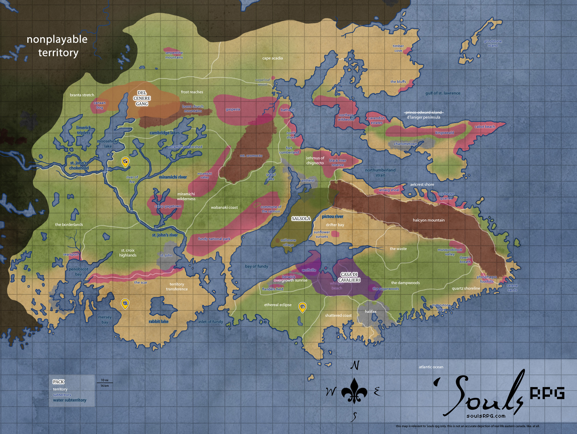
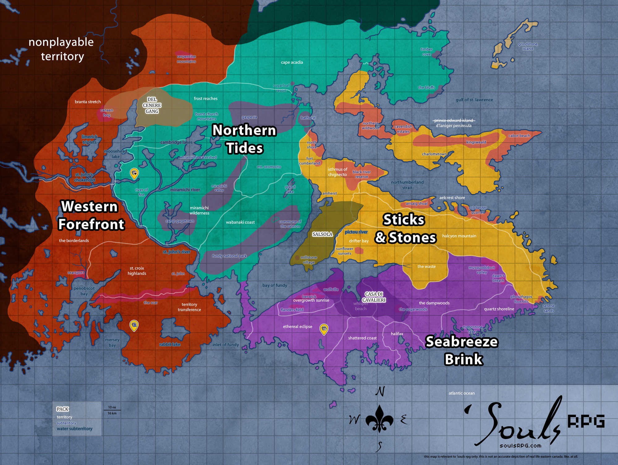
- The largest division of land is a region. For example, Northern Tides is a region. There are 'six regions.
- The next division of land is a territory. For example, Miramichi Wilderness is a territory. There are 27 territories divided amongst the regions. Some territories don't have subterritories -- e.g., Whisper Beach, The Waste, and Black Rock Islands. While subterritories are frequently claimed in whole by packs, claiming of a whole territory is rarer -- only Whisper Beach has been claimed by Casa di Cavalieri (in the timespan of 2008-2013).
- The next division of land is a subterritory. For example, Miramichi Valley is a subterritory. There are 63 subterritories divided amongst the territories, with no more than five subterritories per territory.
- The next division of the land, found only on the Wiki, are "Landmarks." These are generally tiny areas of interest and note within a subterritory. For example, Miramichi Valley has the Landmark of the Miramichi River.
- Once more, that's: Northern Tides > Miramichi Wilderness > Miramichi Valley > Miramichi River.
2. Geographical Region: The Maritime Provinces
'Souls geographical region spans across three Canadian provinces -- Nova Scotia, New Brunswick, and Prince Edward Island -- plus the semi-fictional region of Cape Breton Peninsula. These areas, collectively, may be referred to as the Maritime provinces. All three regions share many similarities. 'Souls fictional version of Eastern Canada bears both clear and subtle differences from actuality -- e.g., Cape Breton is an island in reality, where in 'Souls, it is a peninsula. There are a number of other minor fudges and general differences from reality; you should always rely on 'Souls information instead of real Canadian province information.
2.1 Nova Scotia
- Area: Seabreeze Brink, Eastern Rise, Western Tangles, and part of the Sticks and Stones
- Land Area: SIE FILL DIS IN
- Highest Elevation: Halcyon Mountains -- 1,181 ft (360 m)
- Former Human Population: 746,397 -- 45.9 /sq mi (17.74 /km2)
- Highest Recorded Temperature: 38.3 °C (101 °F) on August 19, 1935
- Lowest Recorded Temperature: -41.1 °C (-42 °F) on January 31, 1920
This peninsula was the primary setting for 'Souls for the better part of ten years. Nova Scotia is completely surrounded by water: the Northumberland Strait to the north, the Cabot Strait to the north, the Atlantic Ocean to the east, and the Bay of Fundy to the west. Nowhere in Nova Scotia is more than 67 km (42 mi) from the ocean. The Isthmus of Chignecto connects Nova Scotia the Canadian mainland, New Brunswick.
Much of Nova Scotia consists of two vast areas set aside as wilderness parks -- the Tobeatic, which spans over The Dampwoods and Arachnea's Revenge, and the Kejimkujik, which spans over Ethereal Eclipse and Serena Reserve. Even just next to the most populous city of Halifax, the Chebucto Peninsula was a protected reserve. One thing Nova Scotia is not short on is open wilderness.
2.2 Cape Breton Peninsula
- Area: Ashes and Ashes
- Land Area: SIE FILL DIS IN
- Highest Elevation: Conquest Bluff -- 1,745 ft (532 m)
- Former Human Population: 89,454 -- 37.04 /sq mi (14.30 /km2)
This peninsula, extending north from Nova Scotia, was the original game setting, and was burned in a wildfire in 2008. As such, the land shows significant evidence of fire trauma and recovery . Most of the plants are pioneer plants, dominating and pushing other species out post-wildfire. Invasive English Oak trees as well as native Paper Birch trees are commonplace in the least damaged areas; Roman Wormwood grows rampantly. The northernmost coast, where the fire started, remains primarily barren and lacks treeland. Significant prey populations are located primarily to the south, along Aelcrest Shore.
The Halcyon Mountains separate the area from mainland Nova Scotia. The primary water influences on this peninsula are the Northumberland Strait to the west and the Cabot Strait, a deep-water strait and part of the Gulf of Saint Lawrence, to the north.
2.3 New Brunswick
- Area: Northern Tides
- Land Area: SIE FILL DIS IN
- Highest Elevation: Mount Oromocto -- 820 m (2,690 ft)
- Former Human Population: 113,454 -- 37.04 /sq mi (14.30 /km2)
- Highest Recorded Temperature:: 39.4 °C (102.92 °F) on August 18, 1935
- Lowest Recorded Temperature: -47.2 °C (-53 °F) on 1-2 February 1992
This area was opened for play at the end of 2011. Much of eastern and northern New Brunswick were unpopulous; regions such as the Fundy National Park were set aside for wildlife and recreational pursuits. Over eighty percent of New Brunswick was forested even prior to the apocalypse; human settlement was limited to the coasts and river systems of the province.
New Brunswick's climate is more similar to that of mainland Canada than Nova Scotia, as the region lacks the ocean's moderating influence. Highland areas in the northern parts of the province can resemble alpine conditions, though the province still falls within the Maritime ecozone. The cold Gulf of Saint Lawrence to the north additionally influences this region's climate.
2.4 Prince Edward Island
- Area: Prince Edward Island
- Land Area: SIE FILL DIS IN
- Highest Elevation: Mount Oromocto -- 820 m (2,690 ft)
- Former Human Population: 140,204 -- 24.77 /km2 (64.2 /sq mi)
Prince Edward Island was beautiful in the time of humanity: rolling hills, thick forests and woodlands, beaches ranging from red sandstone to white silica sand, coves and inlets, and a myriad of other features make the island worth crossing the Northumberland Strait. Rural and pastoral communities made up most of this island community; nevertheless, Charlottetown and the Cavendish Estates areas provide fair evidence of human occupation.
Being northerly, the areas of Prince Edward Island do not suffer fog to the extent of southerly Nova Scotia. Neither are the winters as harsh as mainland Northern Tides areas -- the best descriptor for the area is a mix of the two. The cold Gulf of Saint Lawrence and northerly winds blowing across the gulf contribute to the cold climate of the Island, though it enjoys protection from Atlantic cooling.
3. Geography
The Appalachian Mountains have hilly, poor soil; the coastal Maritime areas are well-fed by the rich tides of the bay and the vast number of inland waterways throughout the region. The inner highlands have acidic soils that support expansive forests, but are not suited for human agriculture; the coastal plains have richer soils.
Acadian forests -- temperate, broadleaf and mixed forests -- dominate much of the south of New Brunswick and Nova Scotia. They consist of four primariy types of forest: alpine communities on the highest mountains, coniferous forests, northern hardwood forests, and wetlands. There are no clear boundaries between the coniferous forests and the hardwood forests; bogs and swampy lowlands are commonplace in areas with heavy riverways and beside lakes.
Gulf lowland forest -- also temperate, broadleaf and mixed forests -- cover east-central New Brunswick and vast parts of Nova Scotia: the Overgrowth Sunrise area; Minas Basin around The Waste and Whisper Beach; as well as the Aelcrest Shore and Isthmus of Chignecto regions. Prince Edward Island, although unplayable, is also covered by this ecoregion.
The warmer climate allows more hardwood trees to grow in the Gulf of St Lawrence than in most of this part of northeast North America, although logging has vastly altered the landscape, introducing invasive trees as well as trees from adjacent ecoregions.
3.1 Glaciation
Glaciation had an overwhelming effect upon the landscape -- much of the terrain is marked by glacial features, including:
- Glacial Erratics: Pieces of rock "that differ from the size and type of rock native to the area in which it rests." Glacial ice dragged these pieces of rock (which can range in size from small pebbles to huge boulders) many hundreds of miles.
- Drumlins are elongated whale-shaped hills formed by glacial ice.
- Eskers are long, winding ridges of sand and gravel, typically raised up from the area surrounding it.
- Sandurs are large, flat outwash plains, typically with sediment, silt, and gravel along most of the area.
- Kettle lakes are shallow, sediment-filled bodies of water formed by retreating glaciers or draining floodwaters, typically formed on sandurs.
- Tors: Sudden rocky outcroppings on an otherwise gentle mountainous or hilly slope. Found everywhere, but especially concentrated in the Burnt Church Mountains.
3.2 Waterways
Coastal Features
Bay of Fundy Coast
- Raised Beaches: (aka marine terrace or perched coastline) An emergent coastal landform. Raised beaches and marine terraces are beaches or wave-cut platforms raised above the shore line by a relative fall in the sea level.
- Sea Stacks: A geological landform consisting of a steep and often vertical column or columns of rock in the sea near a coast, isolated by erosion.
- Headlands: A point of land, usually high and often with a sheer drop, that extends out into a body of water. The word is often used as a synonym for promontory; a headland of considerable size is often called a cape.
Northumberland Strait Coast
- Barachois: A coastal lagoon separated from the ocean by a sand or shingle bar. Salt water may enter the barachois during high tide.
- Rias: A coastal inlet formed by the partial submergence of an unglaciated river valley. It is a drowned river valley that remains open to the sea.
Major Waterways
4. Climate
Proximity to the Atlantic Ocean lends a humid environment with significant precipitation; this is the most active storm region in Canada. The weather consists of skies that are often cloudy or overcast, frequent coastal fog and marked changeability of weather from day to day. Maritime areas tend to be very foggy, with an average of 200 foggy days recorded per year in Nova Scotia. The significant fog found in the Maritime region is due to the interaction of the warm Gulf Stream currents with the much colder Labrador Current; the spring and late summer have more fog than the fall and winter.
Generally, Maritime climate and temperature is more moderate than mainland Canada. The cold winters and warm summers are moderated by ocean influences, though Maritime climates also have a wide but not extreme temperature range. The coastal areas are generally cooler in summer and warmer in winter than the inland regions.
During summer and autumn, coastal Nova Scotia may be struck by tropical storms and hurricanes -- hurricanes strike Nova Scotia roughly once every four years. Most of these storms are rather weak by the time they reach Nova Scotian coast, however. Just twelve hurricane-level storms have hit Nova Scotia since 1871, and most were Category One hurricanes. At least one Category Three1 struck in 1927.
5. Flora and Fauna
Refer to the Flora and Fauna guides.
6. People
Nova Scotia was first inhabited by the Míkmaq people. "The Míkmaq were semi-nomadic. During the summer they spent most of their time on the shores harvesting seafood; during the winter they would move inland to the woods to hunt."
Their pre-contact populations were between 50,000 and 100,000 individuals; during the sixteenth century, as was happening elsewhere, European diseases, wars, and other influences were drastically reducing the Míkmaq's numbers. There was visible evidence of the Míkmaq people prior to humanity's extinction: thirteen communities and reserves -- including one with a population of almost four thousand, the Eskasoni First Nation -- existed on Nova Scotia.
The next largest influence on Nova Scotia was the French. These were among the first European settlers to make their home in Nova Scotia; their influence can be seen in numerous historical sites throughout the region, such as Port Royal in Beast's Grin Peninsula. It was industrialized and modernized along with the rest of Canada as usual, although farming, agricultural, and other natural industries such as logging remained important in numerous areas.
Of course, everything went kaput in 1988, as we all know, and wolves and other canines moved in and took over! :D Approximately sixty percent of the human population resided in the rural areas of the region; the remaining forty percent of that population was clustered directly around the Halifax area in urban, suburban, and rural fashion.
6.1 Post-Apocalyptic Effects
Without humans maintaining dykes and upkeeping other water containment strategies, parts of Nova Scotia flood. The tidal ranges along the Bay of Fundy are very large; they can range up to 15 metres (49 ft). Many of the dykes have been broken, or are in the process of eroding. Areas close to water are especially prone to damage, and will be among the first to collapse and show signs of wear and tear. Many buildings along Halifax's harbour have begun the process of decay.
7. History
The territories have changed notably throughout game history.
- The original Bleeding Souls territories were situated in a nondescript, unnamed area of Canada.
- The original Bleeding Souls territories were abandoned in the 2008 wildfire, while the old Bleeding Souls territories were formally shoehorned into the Cape Breton Peninsula.
- Nova Scotia was slowly colonized by the fire's survivors, with expansions occurring at several times.
- In late 2011, the Northern Tides opened, allowing travel into mainland Canada for the first time.
- In late 2013, the map received a final expansion. The Northern Tides were opened up further, and the Prince Edward Island area was opened for play.
8. Sources
- http://en.wikipedia.org/wiki/Portal:Nova_Scotia
- http://en.wikipedia.org/wiki/Nova_Scotia
- http://en.wikipedia.org/wiki/Category:Geography_of_Nova_Scotia
- http://en.wikipedia.org/wiki/Demographics_of_Nova_Scotia
- http://en.wikipedia.org/wiki/Atlantic_Maritime_Ecozone_%28CEC%29
- http://en.wikipedia.org/wiki/Atlantic_Marine_%28ecozone%29
- http://en.wikipedia.org/wiki/Acadian_forest
- http://en.wikipedia.org/wiki/Gulf_of_St._Lawrence_lowland_forests
- http://en.wikipedia.org/wiki/List_of_extreme_temperatures_in_Canada
- http://www.islandnet.com/~see/weather/almanac/diaryfeb.htm